
Giovanni da Verrazzano, the first European navigator to explore the coast of North America from the Carolinas to Newfoundland, was a perceptive observer. He was thirty-nine in 1524 when the king of France sent him to find a water route through the Americas to east Asia.
Verrazzano’s voyage was not fully understood until a draft of his report to Francis I, with extensive marginal notes by Verrazzano, was found in a private library in Italy and published in Italian in 1909. This document is titled Del Viaggio de Verazzano Nobile Fiorentino al Servizion di Francesco I, Ri de Francia, fatto nel 1524 all’ America Settentrionale. Known to scholars as the Cèllere Codex after the collection in which it was found, the manuscript is now in The Pierpont Morgan Library in New York. Lawrence C. Wroth, a perceptive scholar and expert bibliographer who studied the Cèllere Codex in detail, recognized it as “the earliest geographical, topological and ethnological survey” of the Atlantic coast of what would become the United States. It offers insights into ideas, motives, and ways of imagining the world at the very beginning of American history, written by the first European to explore the Atlantic coast whose impressions survive for us to read. Five hundred years have passed since Verrazzano’s voyage, yet his story still has much to teach us about the ideas and assumptions that shaped the American past.1
II
Verrazzano was a skilled mariner — as were Columbus, Cabot, and Magellan, before him — but he was also a Florentine humanist, schooled in the literature of antiquity but proudly modern, anxious to test theories advanced by the ancients, consider new ideas, and add to the store of inherited knowledge.
Verrazzanno was well acquainted with the geographic ideas of Aristotle and Ptolemy, the ancient writers on whose work the European conception of the world was built. Using astronomy and geometry, the ancients had proved conclusively that the Earth was a sphere, a fact understood by most educated Europeans by the late fifteenth century (educated Chinese, by contrast, continued to believe that the world was flat, or more accurately a low dome, the curvature of which accounted for the perceived horizon). The Greeks had also calculated the circumference of the globe to a remarkable degree of accuracy using the same techniques, though they had lacked the means to confirm this calculation by exploring the world.2

This marble bust of Verrazzano was carved a century or more after the explorer’s death. No contemporary portrait of Verrazzano is known to have survived. National Gallery of Art
These facts were not confirmed through exploration until Magellan’s expedition around the world. It is not clear how much Verrazzano knew about Magellan’s expedition, which had found a way into the eastern ocean by sailing south around America. The ragged survivors of Magellan’s crew — indigenous people killed Magellan in the Philippines in 1521 — arrived in Spain on September 8, 1522, having circumnavigated the globe.3 If anything, Verrazzano would have been encouraged by the story of their harrowing passage through the Strait of Magellan and their interminable voyage across the South Pacific, during which they ate stowaway rats and bits of leather to survive. While eastern Asia could be reached that way, it was clearly not a practical trade route. Assuming, as many scholars and cartographers did, that Asia extended far to the east in the northern latitudes, Verrazzano expected that the northeastern edge of Asia was not far from what we know as the eastern coast of North America.4
Verrazzano explained his aims in the Cèllere Codex:
My intention on this voyage was to reach Cathay and the extreme eastern coast of Asia, but I did not expect to find such an obstacle of new land as I have found; and if for some reason I did expect to find it, I estimated there would be some strait to get through to the Eastern Ocean. This was the opinion of all the ancients, who certainly believed that our Western Ocean was joined to the Eastern Ocean of India without any land in between. Aristotle supports this theory by arguments of various analogies, but this opinion is quite contrary to that of the moderns, and has been proven false by experience. Nevertheless, land has been found by modern man which was unknown to the ancients, another world with respect to the one they knew, which appears to be larger than our Europe, than Africa, and almost larger than Asia, if we estimate its size correctly.
Embedded in this explanation is Verrazzano’s desire to reconcile his findings with ideas about world geography inherited from antiquity. Among these was the idea that the inhabited world consisted of three continents — Europe, Africa, and Asia — and a variety of islands, each of which was assumed to belong to one of the three continents. This division of the inhabited world was reinforced by Christian thought, which held that after the Biblical Flood the three continents had been peopled by descendants of Noah’s three sons. There was no room in this conception of the physical world for additional inhabited continents. Europeans thus generally assumed that the recently encountered lands in the western ocean were islands off the coast of east Asia — including some very large islands, it seemed, but islands that might be navigated around to reach the Asian mainland. Verrazzano, unable to reconcile this received wisdom of the ancients with his own observations, concluded that he had seen “another world with respect to the one they knew.”

Hartmann Schedel’s world map — published in 1493, just as information about the first voyage of Columbus was spreading across Europe — reflects the medieval conception of the world challenged and ultimately overturned by Renaissance explorers. The inhabited world in Schedel’s map consists of three continents, populated by descendants of Noah’s three sons, portrayed in three of the corners. Jerusalem is at the center of the inhabited world. The Indian Ocean is surrounded by land, as it was on several other world maps of the fifteenth century. On the left side, Schedel depicted fantastic monsters believed to inhabit remote lands on the edge of the world. The eastern edge of Asia sought by explorers is not depicted. Sidney F. Knafel Map Collection, Phillips Academy, Andover Mass.
This conclusion was made possible by technical and intellectual innovations of the previous century, which equipped Verrazzano and his peers to challenge and ultimately discard much of the understanding of the world they had inherited. By the end of the fifteenth century western Europeans had acquired — by invention, adoption, or a combination of the two — the techniques needed to conduct long voyages out of sight of land. Just as important, this technical knowledge was possessed by men who regarded it in an instrumental way. The devices they mastered and on which they relied — compasses, vessels rigged to sail close to the wind and built to withstand the rigors of the open ocean, and various astronomical tools for determining latitude (unreliable on the deck of a rolling ship, but useful on shore or in calm seas) — were not philosophical curiosities or aristocratic playthings. They were the tools of intensely practical people intent on minimizing the risks inherent in an uncertain and appallingly dangerous undertaking.5
These tools made it possible for western Europeans to leave the world they knew and explore the unfamiliar, but the tools did not supply the impulse to do so. Chinese navigators had accumulated a great deal of technical knowledge by the fourteenth century and conducted voyages reaching around southeast Asia and India to the east coast of Africa. Their failure to grasp that the world was a sphere hindered their ability to map it accurately, but they might have overcome this misconception. The impulse to explore waned before they did. The Chinese were supremely confident in the superiority of their civilization and little interested in the barbarians they had encountered, who had few things they wanted. The complex civilization of the Indian subcontinent, though it had important trade relationships with the Moslem world and with the peoples of China and southeast Asia, also lacked the impulse for maritime exploration. The possibilities opened for acquiring wealth and status, characteristic of post-medieval western Europe to a degree unknown in other cultures of the time, joined with a rising inclination to test and challenge preconceptions, evident in many areas of European endeavor at the beginning of the sixteenth century, created the impulse for exploration made possible by technological innovations.
Verrazzano did not sail into the unknown. He sailed with preconceptions — some hard facts, some assumptions, some speculations about what he would find. No rational person sets out on a dangerous journey to nowhere, toward some place the very existence of which he is altogether ignorant, without expectations about what he will encounter, even if those expectations are vague and erroneous. The European explorers of the late fifteenth and early sixteenth century ventured in search of places and things the accumulated knowledge of their civilization led them to believe they would find. In many ways what they found was how wrong their assumptions had been and how much rubbish was woven into all that accumulated knowledge. In the process they learned to separate fact from fiction, to test inherited ideas and discard them if they were found wanting, regardless of their source. Simple mariners engaged in route seeking became explorers and explorers became discoverers, in a meaningful sense, by learning to recognize previously unrecognized empirical truths that were contrary to conventional ideas.
III
Verrazzano’s task was finding a route to Cathay, which would become a synonym for China but which in the 1520s generally if somewhat vaguely referred to what we would call northeastern China — Manchuria and its neighbors, in contrast to China proper, the land of the Han Chinese to the south. If such a route could be found he believed he would find it between the northern limit of Spanish activity, around what we know as the coast of South Carolina, and the area around Newfoundland which John Cabot had assumed was the northeast corner of Asia. In 1525 this region was essentially unknown. Some cartographers imagined that north of Florida, America came to an end, perhaps in scattered islands, and that there navigators would find a passage to Asia. If it was there, Verrazzano was intent on finding it.
The dangers Verrazzano and his sailors faced should not be underestimated. He sailed from Dieppe with four ships. He lost two in a storm along with the men who sailed them. He sent the third back to France and sailed on in one small ship, the Dauphine, crossing the Atlantic to strike the American coast near what would later be called the Cape Fear River in North Carolina on March 1, 1524. The Spanish had sailed north of that point without exploring the coast and claimed everything as far as the cod fisheries off Newfoundland already frequented by French and English fishermen. What the Spanish called “Terra Florida” embraced much of what would become the eastern United States, though the French did not respect their claim. “The sun shines for me as it does for others,” Francis I told an emissary from the Spanish king. “I would very much like to see the clause of Adam’s will by which I should be denied my share of the world.”6
Verrazzano sailed south past later South Carolina and then wisely doubled back to the north to avoid Spanish ships, passing Cape Fear and sailing toward Cape Hatteras. He kept his distance from the beach, avoiding shoals that have since claimed hundreds of vessels, but close enough for a man aloft to see over what we know as the Outer Banks of North Carolina, the thin barrier islands that divide the Atlantic from the inland waters of Pamlico Sound.
Pamlico Sound is as much as twenty miles wide — too wide for Verrazzano’s men to have seen the mainland on its western shore — which led Verrazzano to report that they had found
an isthmus one mile wide and about two hundred miles long, in which we could see the eastern sea from the ship, halfway between west and north. This is doubtless the one which goes around the tip of India, China, and Cathay. We sailed along this isthmus, hoping all the time to find some strait or real promontory where the land might end toward the north, and we could reach those blessed shores of Cathay.
There are tidal inlets along the Outer Banks today separating the barrier into separate islands — Portsmouth, Ocracoke, and Hatteras islands, which are bounded by Ocracoke, Hatteras, and Oregon inlets. Inlets naturally open and close along the banks. Vanished inlets are apparent in the fan deltas on the west side of the island chain — evidence that there were more inlets when Verrazzano sailed up the coast, but he apparently missed them all. The larger ones would have provided a passage into what he imagined was the great ocean Magellan had called the “Pacific.”7
The idea that the inland sounds of North Carolina were part of the Pacific Ocean now seems preposterous. The great maritime historian Samuel Eliot Morison was not convinced that Verrazzano believed it. Morison argued that Verrazzano must have been acquainted with the Lido di Venezia, the barrier island that encloses (with the island of Pellestrina) the lagoon of Venice, and that he recognized the waters inside the Outer Banks as a lagoon. Indeed this might have occurred to Verrazzano, but the difference in scale could have misled him. The Venetian Lagoon covers just 200 square miles and the surrounding land is generally within sight. The waters of Pamlico Sound and the sounds connected to it cover some 3,000 square miles and constitute the largest lagoon on the east coast of North America.8
Verrazzano might also have been misled by the experience of Balboa. Searching for gold in what became Panama in 1513, Balboa had learned of a vast sea to the south and found that America, at that point at least, was narrow enough to cross on foot — something like forty miles. Reaching what he called the South Sea, he waded into the ocean and announced its waters and all the lands it touched belonged to the king of Spain, not imagining that he was claiming fully half of the world for his sovereign. If America was that narrow in one place, why couldn’t it be even narrower elsewhere?
It was a mirage. Unable to find what he sailed to find, Verrazzano reported that the route he sought was very close — the waters of the eastern ocean, within reach — separated from the Atlantic by a mile wide ribbon of sand. In his imagination that was all that separated him from the fabled wealth of the Indies.
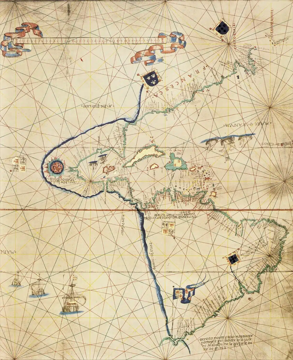
Verrazzano’s observations are reflected in this 1527 map of the Americas by Vesconte Maggiolo, a Genoese, which includes Verrazzano’s narrow isthmus and the “Mare Indicum” (Sea of India) to the west. Maggiolo labeled the region north of the isthmus “Francesca” and decorated it with the royal banner of the French king. Maggiolo also included a reputed straight across Honduras, though he labeled it “Streito dubioso” — doubtful straight. The original of this remarkable map was destroyed when the Biblioteca Ambrosiana in Milan was hit by a bomb in World War II.
IV
As Verrazzano described it, that two hundred mile ribbon of sand was all that connected “Terra Florida” — land claimed by Spain, extending from the Florida peninsula recently explored by Ponce de León north through what we call South Carolina and west to the Pacific, however far away that might turn out to be. Verrazzano focused his report on the land to the north, which he called Francesca, in honor of his royal patron, implicitly claiming the region for France. He recorded his observations with the eye of a naturalist intrigued by the topography, plants, and animals of this other world, so unlike Europe. Verrazzano was the first European to describe the common landscape of what would become the United States and the people who lived there.
He began with the Carolina dunes — “fine sand fifteen feet deep, which rises in the form of small hills about fifty paces wide,” beyond which “we could see a stretch of country much higher than the sandy shore, with many beautiful fields and plains full of great forests, some sparse and some dense” consisting of “palms, laurels, cypress, and other varieties of trees unknown in Europe.” These were maritime forests, dominated by native species — American holly, devilwood or wild olive, American hornbeam, loblolly pine, red maple, and live oak — that would have been unfamiliar to Verrazzano. He found “an abundance of animals, stags, deer, hares; and also of lakes and pools of running water with various types of bird, perfect for all the delights and pleasures of the hunt.” These, too, would have included unfamiliar species, including showy passerines like the Painted Bunting and waterfowl like the Canada Goose and ducks belonging to species never seen in Europe. Further north, in what may have been southeastern Virginia or the Eastern Shore of Maryland, he found the land “much more beautiful and full of great forests.” Verrazzano sailed by day and anchored at night to avoid missing anything of interest.
He was the first European explorer to describe the indigenous people of eastern North America. When they approached the American coast, Verrazzano wrote, “we realized that it was inhabited, for huge fires had been built on the seashore.” Wherever they anchored and rowed boats toward the shore, people appeared — the indigenous people watched them carefully, approached cautiously, and most, Verrrazzano reported, were friendly and generous, offering the Europeans food and on one occasion, saving a sailor who had come close to drowning.
“They are dark in color,” Verrazzano wrote, “not unlike Ethiopians, with thick black hair, not very long, tied back behind the head like a small tail. As for the physique of these men, they are well proportioned, of medium height, a little taller than we are. . . . They are not very strong, but they have a sharp cunning, and are agile and swift runners.” He thought “they resemble the Orientals.” His effort to tie them to Africans or Asians drew on the idea that they must be descended from Noah.
When they entered New York Bay they took a small boat through the Narrows. Verrazzano called the upper bay “a beautiful lake,” though he seems to have understood that this was the estuary of a large river. The local people rowed out to see them, “joyfully,” Verrazzano wrote, “uttering loud cries of wonderment, and showing us the safest place to beach the boat.” Bad weather forced the party to return to the ship before they reached Manhattan, but they had at least glimpsed the finest natural harbor on the Atlantic coast of North America.
Sailing east past Long Island, they reached what we know as Block Island — Verrazzano named it Aloysia, after Louise of Savoy, the king’s mother. From there they entered the mouth of Narragansett Bay, which Verrazzano described as an excellent harbor. Native Narragansett Indians rowed out to greet them. Verrazzano’s crew threw them “a few little bells and mirrors and many trinkets” — a friendly gesture that led the native people to come aboard the Dauphine. “These people are the most beautiful and have the most civil customs that we have found on this voyage,” the explorer wrote, “their manner is sweet and gentle, very like the manner of the ancients.”
Verrrazzano remained in Narragansett Bay for fifteen days — long enough to explore the bay, its five large islands “full of tall spreading trees,” and the nearby mainland where he found mature hardwood forests of widely spaced trees uncluttered by undergrowth. He recognized oaks and eastern red cedar, which he called cypress, but many of the native trees of Rhode Island were unknown to him. Some, like the American beech and American elm had European analogs. Others, like the sweet gum — at the northern end of its range in southern New England —were unfamiliar. He also found fields “open and free of any obstacles or trees, and so fertile that any kind of seed would produce excellent crops.” Although he would not have known it, the Narragansetts probably created these fields by burning off the forest cover.
With a Narragansett guide, he reported, “we went farther inland” and “saw their houses, which are circular in shape, about 24 to 25 paces across, made of bent saplings. They are arranged without any architectural pattern, and are covered with cleverly worked mats of straw which protect them from wind and rain.” These longhouses sheltered as many as thirty people. It was early May — spring in southern New England — and the Narragansetts were busy planting. “when sowing they observe the influence of the moon, the rising of the Pleiades, and many other customs derived from the ancients.”
Verrazzano’s association of their gentle manners and simple way of life with “the ancients” drew on the humanist idea that men had lived simply and in harmony with one another and with nature in an imagined golden age of antiquity. He found much to admire in Narragansett culture. The Narragansett leader he thought was a king wore a deerskin “skillfully worked like damask with various embroideries.” With their simple boats — “a single log hollowed out with admirable skill” — they could move about on the water as swiftly as they pleased. “Their arrows are worked with great beauty” and tipped with sharp stones rather than iron. They lived long, Verrazzano added, and were rarely ill.
They had kings, or so he thought, but they were not members of civil society of a familiar kind. “We think they have neither religion nor laws, that they do not know of a First Cause or Author,” adding that they do not “practice any kind of idolatry.” Indeed Verrazzano found no “temples or churches of prayer” and erroneously concluded that “they have no religion.” Despite that fact, he was deeply impressed by their character. “They are very generous and give away all they have,” the explorer wrote. Their willingness to share, lack of familiarity with commercial exchange, and indifference to gold — they preferred blue beads, little bells, and other things Verrazzano regarded as trifles — were signs that they were incorruptible and in that way a moral example, but also that they were remarkably naïve.
By that point in his journey Verrazzano had probably concluded that a passage to the eastern ocean would elude him, and he began to look at the prospects of the land barring his way. Narragansett Bay, he reported, offered “an abundance of ports and shelter for ships.” The surrounding hills were “full of various blue rocks, crystals, and alabaster” for building. The land was suitable for growing grain, grapes, and olives, Verrazzano wrote, optimistically ascribing to southern New England a Mediterranean climate it did not possess.
Verrazzano left Narragansett Bay and sailed north as far as Newfoundland before turning east to return to France. A shorter version of his report to the king — not as richly detailed as the Cèllere Codex, but exciting nonetheless — circulated among people interested in maritime exploration. His report of an arm of the Pacific Ocean extending east to sandbanks on the Atlantic coast of North America reached cartographers who depicted it on their maps, some labelling it the Mare de Verrazana — the Sea of Verrazzano.9
He had failed to find a route to Cathay, but reported that he and his crew “had discovered seven hundred leagues or more of new land” (“havendo discoperto leghe sectecento et piu di nuova terra”).
It was not, strictly speaking, true. The ancestors of the American peoples Verrazzano encountered had reached the eastern seaboard of North America thousands of years earlier, and in the very limited sense in which being the first people to see something is discovery, those ancestors had discovered it. But it seems certain that they were not aware that they had reached a place no person had ever been and that they had no comprehension that it was part of a vast land that was different in some meaningful way than the land from which they had come. They undoubtedly had attachment to place but no orderly strategy for accumulating, recording, and sharing information about places new to them. They had no sense of geography of any formal kind, nor did their descendants who encountered Verrazzano and other Europeans mariners. Their sense of place was not necessarily limited to a narrow locale — some of them hunted or otherwise ranged over large areas and accumulated knowledge of distant places that were passed on in traditional ways through oral means. Some were nomadic, but even the nomads did not deliberately set out to cross from the known into the wholly unknown. Their world changed incrementally.
Discovery requires comprehension — a sense of the nature of the thing perceived — its magnitude and limits and its relationship to things of a similar kind. In this sense Columbus did not discover America. His arrival in the Americas marked the beginning of a period of cultural exchange and upheaval of extraordinary importance, but he did not comprehend the nature of the Americas, which he believed was part of Asia. The discovery of America was the collective achievement of explorers over some forty years. Together they accumulated, recorded, and shared information about what they had observed, leading to Verrazzano’s conclusion that the land they had explored was a vast continent previously unknown to Europeans, “another world” distinct from Europe, Africa, and Asia.10
Nearly five hundred years have come and gone since Verrazzano explored the east coast of North America, hoping to find something that was not there. It was not land that Verrazzano discovered. It was a truth — that what would soon be called North America, whatever the ideas inherited from the ancients might suggest, was not an island, or a group of islands. It was a continent — a world unto itself, filled with unfamiliar plants and animals and home to remarkable people. Five hundred years later we are still exploring it, working to discover the everyday wonders in the common landscape of America.
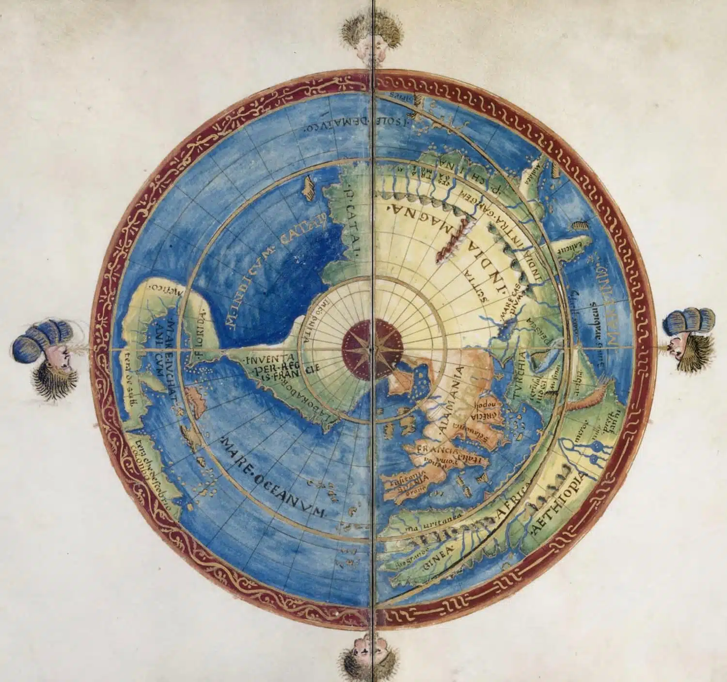
Battista Agnese avoided depicting America as a separate continent by attaching it to Asia by an imaginary land bridge in this polar projection of the Northern Hemisphere executed in Venice in 1544. He labeled the region north of Verrazzano’s imaginary isthmus “Inventa per Regis Francie” — Discovered by the King of France. Biblioteca Nacional de España
Notes
- On the Cèllere Codex, see Lawrence C. Wroth, The Voyages of Giovanni da Verrazzano, 1624-1528 (New Haven: Published for The Pierpont Morgan Library by Yale University Press, 1970), x, 94. Lawrence Wroth spent forty-three years (1923-1957) of his scholarly life as the librarian of the John Carter Brown Library — an international treasure and home to the greatest collection of printed materials about the Americas published before 1800. This exquisite work of scholarship presents a facsimile of the manuscript, a transcription in the original Italian, and a lively English translation by Susan Tarrow, a distinguished linguist. All references to the codex are from this translation, found on pages 133-42. The body of the document is in a clerical hand — apparently a copy of an earlier draft of Verrazzano’s report to King Francis I. Wroth was confident that the annotation was added by the explorer himself. [↩]
- Christopher Cullen, “A Chinese Eratosthenes of the Flat Earth: A Study of a Fragment of Cosmology in Huai Nan tzu,” Bulletin of the School of Oriental and African Studies, University of London, vol. 39, no. 1 (1976), 106-27. [↩]
- In 1528, Antonia de Silveiri de Meneses, Portuguese viceroy of Mozambique, wrote that someone named “Joam de Varamsano” was at Lisbon with Magellan in 1517 and accompanied Magellan to Castile. This raises the possibility that Verrazzano knew Magellan and may have been involved in his plans in some way. See Wroth, Voyage of Verrazzano, 9, 29. Verrazzano probably read the account of Magellan’s voyage by Maximilianus Transylvanus, secretary to Emperor Charles V, who interviewed the survivors and wrote De Moluccis Insulis, published in Cologne in January 1523 and republished in Paris in July. For this work, see Emmanuelle Vagnon, “Maximilianus Transylvanus et Pietro Martire d’Anghiera — Deux humanistes à la cour de Charles Quint,” Anais de História de Além-Mar, vol. 20 (2019), 216-46. [↩]
- The assumption that the mainland of Asia, north and northeast of Japan, reached as far east as the meridian of Mexico informed Portuguese and Spanish cartographers through the first quarter of the sixteenth century. The land mass depicted in the northeast corner of the Cantino Planisphere (a map copied and smuggled out of Portugal and taken to Italy), which reflects the most advanced Portuguese knowledge when it was drawn in 1501 or 1502, is located northeast of the Caribbean and would seem to be North America, but it seems more likely to have been intended as a peninsular part of east Asia, which was consistent with John Cabot’s conclusions following his 1497 voyage. [↩]
- On the technological developments that made overseas voyages possible, see J.H. Parry, The Establishment of European Hegemony, 1415-1715 (New York: Harper & Row, 1961). Parry combined extraordinary erudition with graceful prose. His books are a fine place to begin exploring what he called “the age of reconnaissance.” [↩]
- Henry Percival Biggar, ed., A Collection of Documents Relating to Jacques Cartier and the Sieur de Roberval (Ottawa: Public Archives of Canada, 1930), 189-92, quoted in Jacques Lacoursière, Canada-Québec Synthèse Historique, 1534-2000 (Sillery, Québec: Septentrion, 2005), 28. [↩]
- Shortly after making landfall reported finding “streams and inlets from the sea” which some writers have mistakenly identified as inlets along the Outer Banks. The region Verrazzano was describing was somewhere between Myrtle Beach and Cape Lookout. The evidence for this is that after describing the region Verrazzano reported that “We left this place and continued to follow the coast, which we found veered to the east,” which can only refer to the coast between Cape Fear and Cape Lookout, which forms a clockwise arc to the east before making a sharp turn to the northeast at Cape Lookout. There are no barrier islands at Myrtle Beach and those between Cape Fear and Cape Lookout, which are divided by numerous inlets, are very close to the mainland and should not be confused with the Outer Banks between Drum Inlet (midway between Cape Lookout and Ocracoke) and modern Oregon Inlet, which enclose the broad expanse of Pamlico Sound. Verrazzano did not find an inlet in this northern part of the barrier island chain, probably because he sailed too far offshore to recognize one. This conclusion is shared by William P. Cummings in The Southeast in Early Maps (Chapel Hill: University of North Carolina Press, 1962). For a graceful introduction to the evolution of the Outer Banks, see Dirk Frankenberg, The Nature of the Outer Banks (Chapel Hill: University of North Carolina Press, 1995). [↩]
- Samuel Eliot Morison, The European Discovery of America: The Northern Voyages (New York: Oxford University Press, 1971). [↩]
- In addition to the Maggiolo map of 1527 (illustrated), Verrazzano’s brother Girolamo, who may have accompanied the voyage, drew a massive world map on vellum (102 inches by 51 inches) in 1529 (now much faded and on display in the Vatican Museum) that includes the false sea. Given its similarity to the Maggiolo map of 1527 it seems likely that Girolamo drew an earlier map to which Maggiolo had access. Maggiolo himself drew a second large world map completed 1531 that it included the false sea. This 1531 map was long part of a private collection in Britain. It was acquired by British dealer, Daniel Crouch, in 2016 and acquired in 2017 by the Louvre Abu Dhabi (a detail from this map depicting the false see is on the homepage). The false sea also made its appearance on the bronze globe made by Euphrosynus Ulpius, now in the New-York Historical Society, the Robertus de Bailly globe, made in 1530 (three versions are known, in Bibliotheque Nationale in Paris, the Museo Lazaro Galdiano in Madrid, and the Pierpont Morgan Library in New York), and the so-called Florentine Goldsmith’s Map, made in Florence or perhaps Venice around 1550, now in the John Carter Brown Library.
Italian mapmakers were more inclined to accept Verrazzano’s claim to have glimpsed the eastern ocean from the North American coast. The Spanish and Portuguese ignored Verrazzano’s claim. Even the French cartographers in Dieppe rejected the sea of Verrazzano. No hint of Verrazzano’s sea appears on the elaborate world map of Jean Mallard, completed around 1540 and now in the British Library. Guillaume Brouscon appears to have avoided the issue in his 1543 world map by placing a large compass rose over the spot. The sea does not appear in the beautiful 1547 portolan atlas of Nicholas Vallard. Both of the latter are in the Huntington Library. Nor does the sea appear on the magnificent 1550 world map of Pierre Desceliers now in the British Library.
After mid-century the idea of a great sea reaching to the Atlantic coast appealed to English mapmakers and promoters of English colonization in North America, including Richard Hakluyt, Michael Locke, and John Dee. The latter’s 1582 map depicting the false sea (and other waterways to the Pacific through the arctic) is in the Free Library of Philadelphia. The “Mare de Verrazana” appeared prominently in the map of North America in Richard Hakluyt’s Divers Voyages touching the Discovery of America, published in 1582 to promote English colonization. [↩]
- For a different view of Columbus as a discoverer, see Felipe Fernández-Armesto, Columbus (New York: Oxford University Press, 1991), 189-93. [↩]
